• General
• General
What is PFAS?
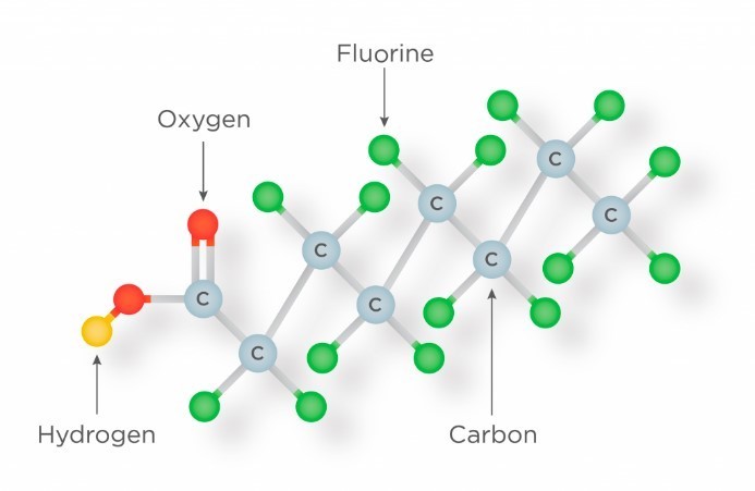
PFAS is the name given to a wide family of perfluoroalkyl and polyfluoroalkyl compounds, illustrated to the left. These chemical compounds are important for their endurance and resistance to hydrocarbons, water, harsh chemicals, heat, and fire.
History of PFAS?
Industrial companies began manufacturing PFAS compounds in the 1950s. The demand for these compounds was attributable to their vastly improved protection of surfaces from the conditions outlined above.
The United States Navy started researching better ways to extinguish fires in the 1960s, the resulting product was termed aqueous film forming foam (AFFF). According to pfasfacts.com, “The Navy patented the technology and required its vessels carry AFFF to protect the lives of U.S. sailors, airmen and flight officers after 134 sailors died in a fire aboard the USS Forrestal in 1967. To this day, the military specification governing AFFF requires the use of PFAS-based surfactants given their unique and life-saving properties.”
Where is PFAS?
The following list is provided from pfasfacts.com.
Satelytics can now detect and quantify PFAS
Satelytics has identified a unique spectral fingerprint for PFAS. Figure 1 shows a time sequence observation of PFAS's signature using spectral analytics.
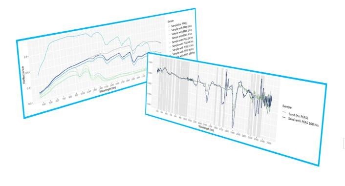
Figure 1 - left
Figure 2 - right
The analytics are correlated, in Figure 2, to sensors that are currently available on a satellite or other aerial platform able to capture the necessary area of interest. The anatomy of an algorithm identifies the spectral signature for direct light reflectance, also corroborating elements and even surrogates for continuous improvement in accuracy and quantification. The software and science analytics are correlated to ground samples, which are measured by an independent laboratory.
Algorithms are built for both land and water, and render on the satelytics.io software platform — allowing not only detection, but MEASUREMENT of the desired constituent, often down to PPT concentrations!
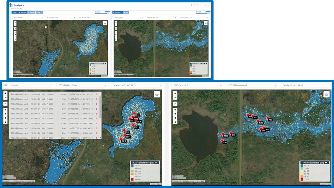
Figure 3. PFAS compounds measure on land and water, EVERY PIXEL, EVERY TIME, and even extracts data points to feed other software and reporting applications.
Satelytics Inc., www.satelytics.com, is a cloud-based geospatial analytics software suite. Multispectral and hyperspectral imagery is gathered from satellites, UAV, planes, and fixed cameras, and processed to provide both alerts and qualitative results for our customers. Data can be gathered up to a daily basis, and results are sent to customers within hours. This includes the specific problem, location, magnitude, and even qualitative information, which minimizes cost, impact, and operational disruption for our clients.
For more information, contact David Dunham, ddunham@satelytics.com, (o) (419) 728 0060 extension #101, (c) (701) 213 0294.
We use cookies to analyze our web traffic and to enhance your experience. By continuing to view this website, you agree to our use of cookies.
Our Privacy Policy