• Electric & Gas Utilities
• Electric & Gas Utilities
(This is a condensed version of an article published in Smart Energy International
on August 16, 2024.)
America’s utility infrastructure, especially in rural areas, is vulnerable if the correct protections are not implemented. The slightest spark can trigger power outages, wildfires, and infrastructure damage. This potential is far from a remote concern: according to the Federal Energy Regulatory Commission (FERC), vegetation is one of the leading causes of electric service outages. When vegetation around power lines is not monitored, it can spell disaster for businesses and surrounding communities.
It’s not surprising, then, that utility vegetation management (UVM) is projected to swell to a nearly $40 billion industry by 2029: few services are more urgently needed and have more of an impact on Americans’ day-to-day lives. That urgency helps explain the drive towards innovation in the industry, with utility organizations working in concert with technology companies to implement cutting-edge technology to improve UVM efforts nationwide and ensure that communities are kept safe.
Satelytics works with utilities, using the latest AI and machine learning developments to apply algorithms designed to help determine where and when to cut down trees and vegetation encroaching on utility lines with a high level of granularity. One recent project near Indianapolis analyzed several considerations, including proximity to the corridor and wire zone, tree height, health, and type. The results of this project provide a glimpse into the direction of the industry.
The first assessment, conducted in October 2022, was tasked with determining whether any trees were growing into danger zones, divided into two categories – wire zones and strike zones.
The wire zone designates the area directly under the widest portion of a transmission line. The wire zone was analyzed by measuring the distance between the pole and the line. When trees grow into that wire zone, there is an increased risk of adverse consequences like loss of power and wildfires.
Beyond wire zones, a clearer picture of strike potential is needed. Heat, wind, and electrical load cause power lines to sag and sway, bringing them outside the designated wire zone and potentially into contact with vegetation. Threats within this strike zone are analyzed because they present the same increased risks posed by wire zone threats.

Determine which individual trees pose strike potential.
The initial analysis in Fall 2022 was staggering, producing 200,651 detections of trees within the two danger zones. These alerts were coupled with information on tree height and type. While the issue of identifying trees that threatened electrical infrastructure was solved, the resulting number of alerts presented a new challenge: prioritizing 200,651 alerts.
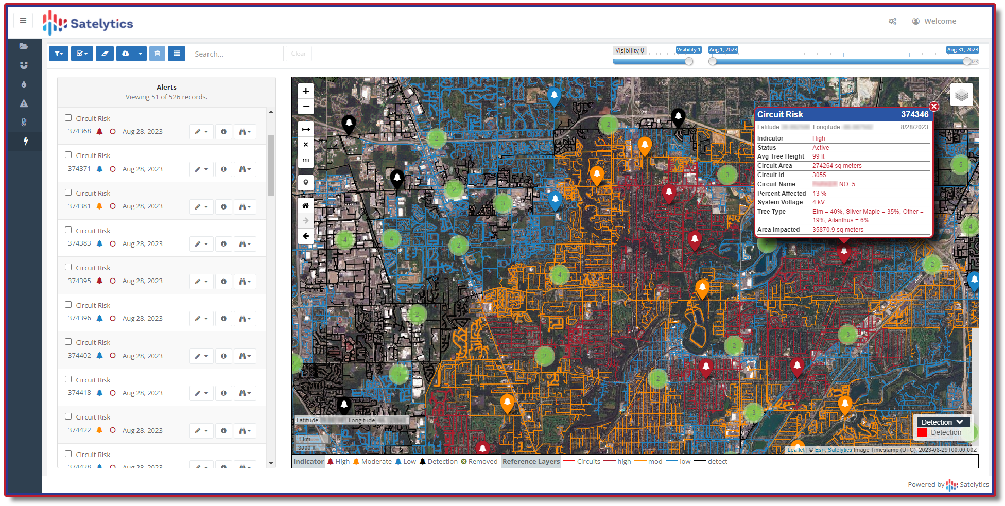
To address this problem, Satelytics developed a heat map to pinpoint ‘hot spots.’ On this heat map, areas with many alerts were colored a bright red, whereas areas with fewer alerts were represented in blue. This allowed the customer to allocate their resources better and ensure that the most urgent threats were addressed first.
Tree speciation, health, and growth all influence the degree of risk a tree is to utilities. Some species of trees are more robust than others, able to weather blights and changes in climate. A hearty tree will not fall under normal circumstances, but one more susceptible can become a risk to adjacent electrical infrastructure. Likewise, tree growth over time can increase risk.
The first analysis was conducted after the leaves had fallen. The second analysis was conducted while the trees had all their leaves. Both stages offer the chance to collect important data, but the benefit of analyzing trees with their leaves is that tree health can be more thoroughly examined. Accordingly, the employed algorithms assess all vegetation factors with unprecedented granularity.
Satelytics analyzed the spectral signatures of individual trees, delivering specific data about individual trees to the customer, i.e., not just ‘deciduous’ or ‘evergreen’ but ‘this is an unhealthy, 49-foot silver maple tree.’
This time, the analysis resulted in 49,505 alerts. These were also prioritized to optimize field crew intervention. This process was significantly aided by developing a ‘circuit risk’ product for an optimized, rotating schedule of tree-cutting, ensuring the highest-risk circuits would be addressed first. These analyses enabled the companies to grade the risk level of each circuit, analyzing the percentage of stressed versus healthy trees, which allowed crews to direct their attention to those trees that posed the biggest threat to electrical infrastructure.
Plan trimming work over coming years with circuit risk analysis.
The problems identified by the results of these analyses would have been impossible to address without AI/ML algorithms. Inevitably, traditional methods are limited by available workforce. Even the most lavishly resourced utility companies cannot afford to spend the billions it would require to hire and maintain a staff large enough to identify every problematic tree in a given area.
The success of this case study is an affirmation of the motto, ‘The more data, the better.’ By gathering and instantaneously analyzing vast quantities of data, AI/ML-enhanced UVM initiatives can provide clarity that was inconceivable just a few short years ago.
The damage caused by untended vegetation is incalculable; a single neglected tree can cause consequences that damage surrounding homes and claim lives. The cost to communities is too high for utility companies not to embrace the latest UVM technology.
Call us today to explore how your company might harness geospatial analytics for UVM, benefiting your bottom line and the community.
We use cookies to analyze our web traffic and to enhance your experience. By continuing to view this website, you agree to our use of cookies.
Our Privacy Policy