• Electric & Gas Utilities,Pipeline Operators
• Electric & Gas Utilities,Pipeline Operators
(adapted from an Airbus article released on 6/11/2024; read the full article here)
Southern Company, one of the largest utilities in the U.S., is known for relentlessly pursuing new techniques for delivering services more efficiently to ratepayers across its three-state service territory. Its Research and Development group conducted a corridor encroachment monitoring project with Satelytics between 2019 and 2021 in Georgia.
Southern Company owns the rights-of-way (where electrical transmission line corridors are located), but not the properties. Therefore, Southern Company must patrol the corridors year-round to monitor whether people are building in the right-of-way. Encroachment into the corridor is usually accidental, involving a landowner who incorrectly judges the right-of-way lines and builds a barn, parking lot, or other structure within the boundaries too close to the transmission lines. If not corrected in time, the utility may be forced to downgrade the affected lines so they don’t strike the structure during periods of sag or sway. Not only can such an encroachment pose danger to the property owner, but the line downgrade can be costly to the utility.
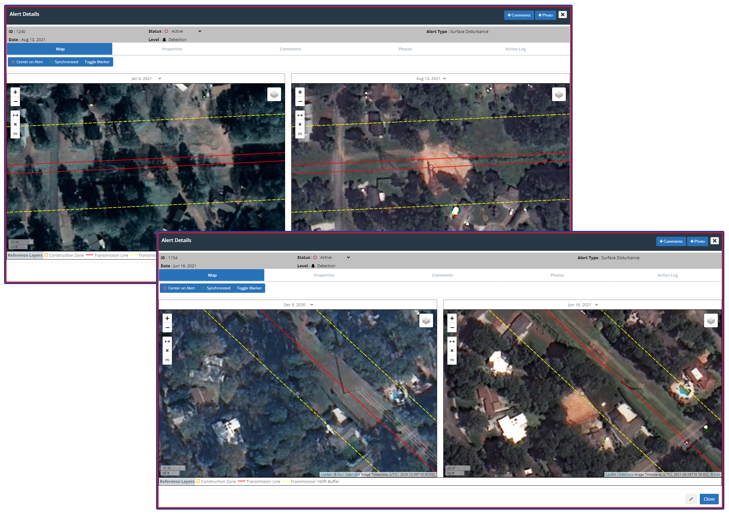
Satelytics' algorithms identify construction progress.
Southern Company’s goal with the project was to expedite the field patrols and explore operational efficiencies afforded by employing geospatial analytics. They also hoped to reduce the number of field visits required to ensure safe operation.
The key is finding the construction in its early stages when moving the structure is still possible. Monitoring the corridors with vehicles, aircraft, and drones is done, but usually not with the frequency required to spot an infraction in time. The utility’s service territory includes thousands of miles of right-of-way, some of which are inspected only every few years.
To identify encroachments, Satelytics and Southern Company analyzed high-resolution satellite imagery on a quarterly monitoring schedule. High-resolution imagery is critical for Southern Company because it helps their personnel determine how best to deal with the incursion with great detail. Some small encroachments might be ignored while others may warrant a phone call to the landowner or a site inspection by a utility official to determine if the construction violates safety clearances. AI-based algorithms detected changes in the imagery, such as new barns, parking lots, pools, and houses built in the right-of-way. Another major advantage of the change-detection process is that it identifies land disturbances that often precede construction.
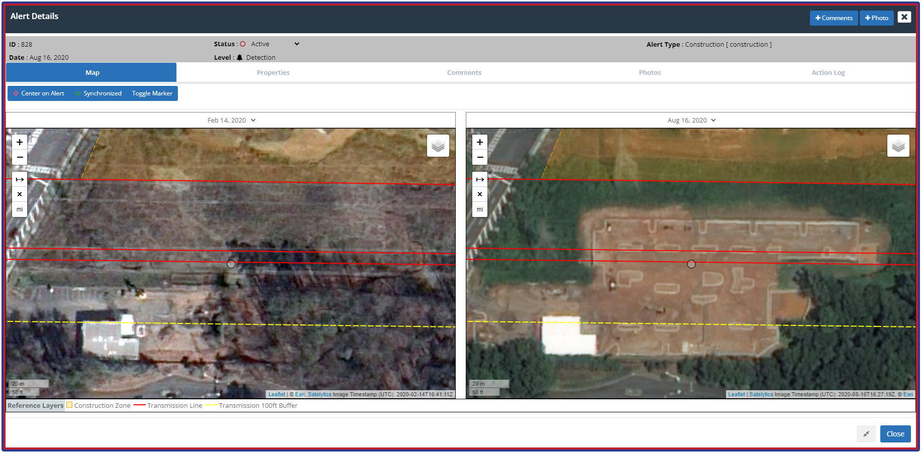
High-resolution imagery analyzed to provide accurate measurement of encroachment.
The Southern Company team compared Satelytics alerts with what they observed in field visits. In some cases, the construction technically violated the right-of-way but didn’t interfere with safety clearances. Southern Company provided this feedback to Satelytics, which used the information to fine-tune its AI analytics. By the end of the pilot, the AI-generated alerts were flagging only those encroachments that posed a danger to people or a problem for the utility.
Southern Company is now presenting the results to its operating companies so they can determine how best to implement the approach company-wide. Want to learn more about how you can harness geospatial analytics to improve your operations? Give us a call!
We use cookies to analyze our web traffic and to enhance your experience. By continuing to view this website, you agree to our use of cookies.
Our Privacy Policy